You surely use Google Maps. That's good, but we bet you don't know all the hidden tricks! Here is our pick of the best tips for getting the most out of Google's mapping service. Follow the guide to get the most out of it, never get lost again, but also discover new things!
 Summary
- Switch Google Maps to Dark Mode
- Display the number of COVID-19 cases / location of vaccination centers
- Find the price of gasoline based on gas stations
- Find wheelchair accessible routes
- Check the peak hours of a restaurant, store or bar
- Display the speedometer in Google Maps
- Google Maps lets you know when you need to get off the bus or train
- Listen to music directly in Google Maps
- Find out where the self-service bike stations are located
- Share your location with your friends
- Download maps for offline viewing
- Use voice navigation
- Navigate hands-free
- Use the OK Google command to navigate in Google Maps
- Explore the surroundings of a place
- Know which district is the most touristy near you
- Know the low carbon zones and their particularities
- Save your favorite places
- Give personalized names to your favorite places
- Remember where you parked your car
- Access your location history
- Access Street View via smartphone
- Place a marker on the map
- How to add stopovers to your route on Google Maps
- Navigate in augmented reality with Google Maps
- Google Maps can save your home and workplace
- Comments
Google Maps is the ultimate mapping tool. It is available by default on Android smartphones and tablets, on the web and even in the Apple App Store through an application for the iPhone and iPad (since the arrival of Apple Maps) . But do you really know all of its intricacies? Here are some tips on how to use it better.
Switch Google Maps to Dark Mode
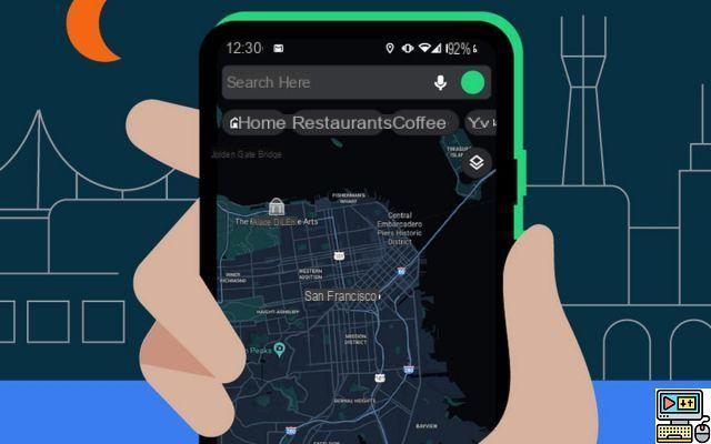
Dark mode is finally available in Google Maps. This mode is a kind of skin that's gentler on the eyes and on battery life (at least on smartphones with an OLED screen). To activate it:
- Open the Google Maps app
- Click on your Google profile icon (top right next to the search bar)
- Go to Parameters
- See you in Theme
- Press Still dark theme
Display the number of COVID-19 cases / location of vaccination centers
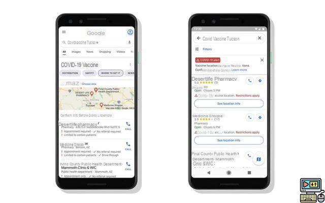
Google is adding features that help fight COVID-19. This makes it very easy to find a vaccination center in Google Maps. To do this, just look for the words COVID vaccine in the application.
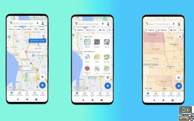
Note also that the number of COVID-19 cases can now be displayed on the map. To activate the option, you have to go to the upper right corner of your smartphone screen and simply touch the “COVID-19 info” option. Also, be aware that Google is currently testing the display of population affluence in the streets. For now, this feature is only available in New York and Sidney, but the American company plans to deploy it in other cities around the world soon, including Paris.
Find the price of gasoline based on gas stations
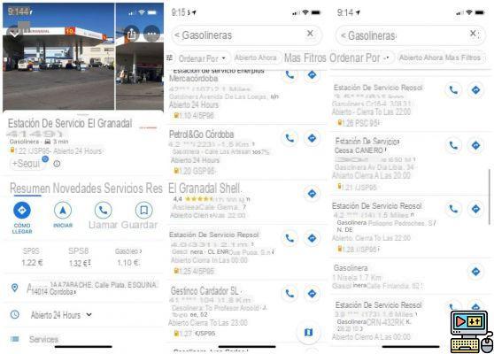
The display of fuel prices is gradually being deployed in Google Maps. All you have to do is search for the keyword “gas station” to display the list of nearby stations with the price of fuel. Useful to find the cheapest gasoline!
Find wheelchair accessible routes
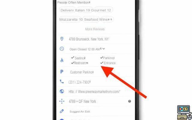
Google Maps makes it possible to find routes that are easily accessible to people in wheelchairs. The application will display on each route if there is easy access for people with reduced mobility, such as metro stations with ramps for example. Here is how to do it:
- Find the desired route
- Choose the option “Public transport” (tram icon)
- Press Options
- Select Wheelchair accessible
- Go back
- The routes listed are accessible to wheelchair users
- Select the route that suits you best
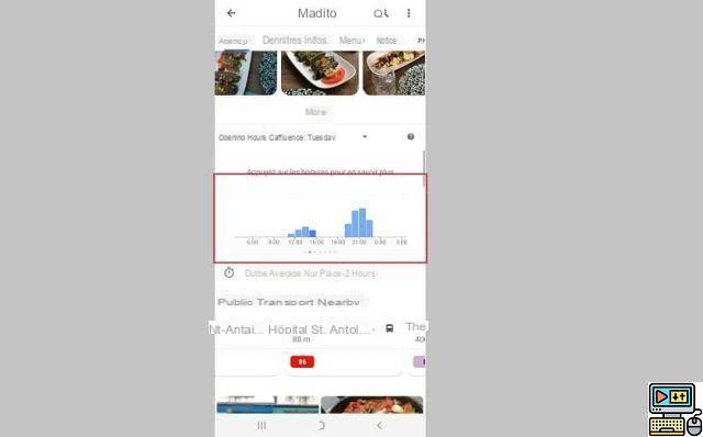
Check the peak hours of a restaurant, store or bar
Before heading to a bar, restaurant or your favorite video game store, do you often wonder if the place is packed with people? Google Maps can answer this question! To avoid queuing before entering a trendy brasserie or café, all you need to do is check the rush hours directly in the app. Maps will then provide you with an overview of the average frequentation of a public place at the time of your choice. We explain how to do it:
- Type the name of your destination in the search bar
- Click on the location file
- Go to Busy times
- Choose a day of the week and a specific time
Note also that Google intends to soon deploy new rating options for restaurants. Users can for example mention the price of the menu, the speed of the service, if the establishment offers take-out sales or not. Available for now in the United States, these new options should arrive soon in other regions of the world, including Spain.
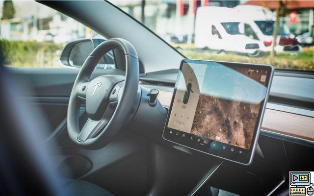
Display the speedometer in Google Maps
Google Maps allows you to monitor your speed with a speedometer. Obviously, this meter is only intended for car mode. We explain how to activate the Google Maps speedometer:
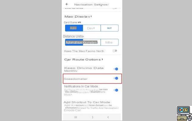
- Go to the menu ≡ on the top corner left
- Go to Settings> Navigation settings
- REACH Speedometer in the section Driving route options
Google Maps lets you know when you need to get off the bus or train
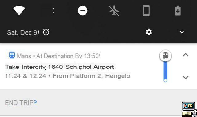
Google Maps can warn you when you need to get off a bus or train, the option, accessible directly from your smartphone notifications, tells you a little before when you need to get out of the bus or train, by depending on your destination.
For it :
- Simply launch a public transport route and tap Start
Listen to music directly in Google Maps
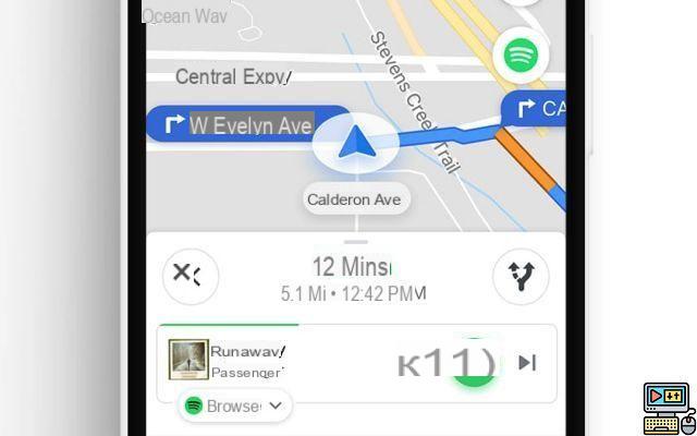
Google Maps allows you to play music on Spotify, Apple Music and YouTube Music directly in the interface of the app. This is particularly useful when driving by car: you no longer need to switch from one application to another.
We explain how to activate the audio player:
- Start a driving route by pressing Start
- Go to Parameters (at the bottom of the interface)
- See you in Audio playback controls
- Choose your music streaming service
- An audio player now appears just below your route information
Find out where the self-service bike stations are located
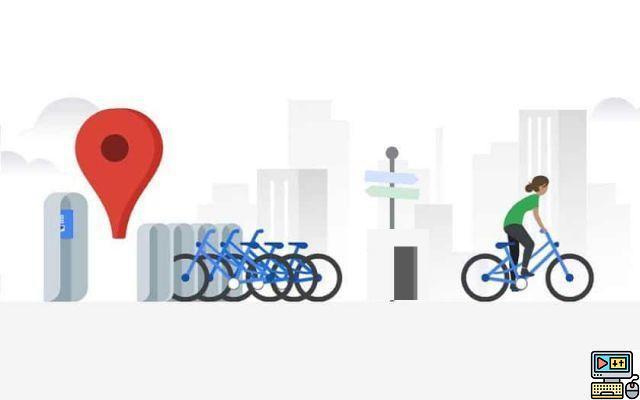
Google Maps shows the bike-sharing stations available nearby in 24 cities, including Lyon and Brussels. The application also indicates in real time how many bikes are still free in each station.
To see the bikes on the map, all you need to do is be located in an eligible city.
Share your location with your friends
Share your location, admit that it's still very practical when your friends have to join you. You send them the GPS data by messages and then they just have to use Google Maps to find out which route to take to reach you. In the process, Google Maps also provides the percentage of battery remaining on your smartphone in real time.
Here's how to proceed:
- Open the application Google Maps
- Go to the side menu
- Select Position sharing
- Click on Start
- Select the duration for which you want to share your location
- Then choose the person with whom you want to share your location
- Click on Share
- The battery indicator will be displayed on your contact along with your location
Download maps for offline viewing 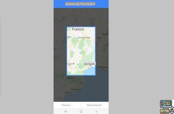
Google Maps integrates offline navigation, so it is possible to download areas and consult them later. Very handy when the mobile network is lacking!
To do this, all you need to do is:
- Open the side menu of Google Maps
- Press the option Offline maps
- Press Select your own plan
- Drag the screen frame to the area you want to download
- Push the button Download at the bottom right
To discover : Our top best offline Android GPS devices
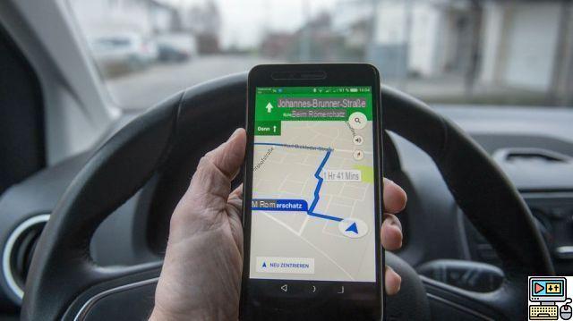
Use voice navigation
Google Maps can turn your Android smartphone into a real car GPS. All you have to do is select a route and you are then guided by voice with a map and a marker that follows your route. It is extremely practical for motorists. Here is how to do it:
- Click on the microphone at the top right then enter an address by voice
- Click on the button at the bottom right to select your route. Check that the car is selected as the mode of transport if it is a car trip.
- Click on the arrow at the bottom right to start navigation
- Let yourself be guided
- Note that if the car is already selected as the mode of transport, you only need to press and hold the icon representing the mode of transport to directly access navigation.
To discover : our selection of the best GPS for Android
Navigate hands-free
When you're behind the wheel, it will be particularly interesting to be able to launch Google Maps without touching your phone so that you can then navigate hands-free. And it is quite possible, all you have to do is allow your smartphone to activate voice control from all screens. If it's a recent smartphone, there shouldn't be a problem. Here is how to do it:
Activate OK Google from the lock screen
- Launch the app Google
- Click on the button Plus at the bottom right
- Select option Parameters and Voix
- Check the boxes From any screen et Personalized results
Use the OK Google command to navigate in Google Maps
Once the “OK Google” function is activated, you will be able to launch Google Maps without touching your phone, even if it is locked. All you have to do is say the following voice command:
- « OK Google, lance Google Maps »
The application then opens on your smartphone. Unfortunately, the voice control of the service still has its limits and once on Maps, you will have to press the microphone icon to be able to speak a place or an address by voice. Likewise, if you say the phrase "take me to such and such an address" from the OK Google voice command, you will still need to click the "Start" button from the search results to start browsing.
To discover : how to use Google Maps in GPS like a pro
Explore the surroundings of a place
When you are on vacation or traveling in a city you do not know, it is possible to obtain the list of strategic places around the one in which you are, such as restaurants, shops or even cinemas. To do this, all you need to do is:
- Click in the search bar to open the menu
- Select option Explore the surroundings
- Below you will also find a list of strategic locations
Know which district is the most touristy near you
Google Maps allows you to direct you to the most touristic neighborhood in the area: the application offers a short description of the neighborhoods that surround you when you are in the city. To have access to these few tourist tips, all you need to do is:
- Go to the menu Discover
- Click on the small gray arrow to the right of the zone name
Know the low carbon zones and their particularities
Since 2020, some Spanish metropolises, including Greater Paris, have become low carbon zones. Three were created in 2020 (Paris, Lyon and Grenoble) and seven others (Aix-Marseille, Nice, Toulon, Toulouse, Montpellier, Strasbourg and Rouen) should join them before the end of 2021. This means that certain vehicles can no longer drive there on certain days or at certain times.
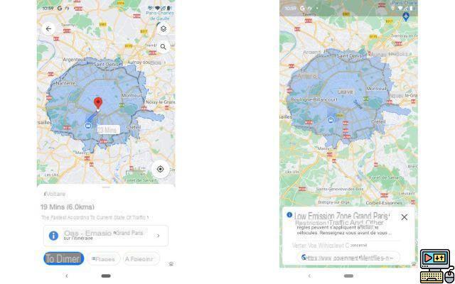
An update of Google Maps, pushed in July 2021, allows low carbon areas to be taken into account when calculating a route. When a route passes through one of these areas, the route preview alerts the user and displays the area. Its alerts are contextual. They take into account the nature of the zone (Crit'Air sticker numbers authorized, day and time of restricted traffic) and the model of the driver's vehicle (if the user has provided the information).
In the event of a restriction, if the route crosses the area, but does not end there, the application may suggest an alternative route. If the trip is entirely in the area or if its destination is located there, Google Maps is now able to offer an alternative to the car (public transport, VTC, urban mobility solution). In July 2021, only the Paris area was supported in Spain (and four others in Europe).
Save your favorite places
Imagine, for example, that you go to a place you want to return to, but you are not sure where to find the address. To do this, you just have to save it within the application by proceeding as follows:
- Click on the address at the bottom
- Click on the star "Save"
- Once the place has been saved, the blue star will turn yellow and the application tells you that the place has been saved to your addresses
Give personalized names to your favorite places
Your home and workplace are the two most important places to enter in the app, but they're not the only ones. Fortunately, it is completely possible to personalize other places you visit regularly, such as your hairdresser or the addresses of your friends. To do this, all you need to do is:
- Enter an address in the application's search bar or pin a location using the blue dot
- Touch the address
- Click on the "Three dots" button at the top right to open the settings
- Select "Add a label" and enter the name of your choice
Remember where you parked your car
Do you tend to forget where you parked your car, especially when traveling to a city we don't know? Google Maps can save the exact location where you left your vehicle. For that, you just have to:
- Park your car somewhere
- Click on the blue dot that represents your location on the map
- Choose Set as parking place
- A message You are parked near here is then displayed here
- You can clear the location just by clicking on it
Access your location history
It's a fact, Google Maps memorizes all the places you go to and all your journeys. It's handy for those with no memory, but do you know how to access location history? It's pretty easy, just follow these steps:
- Open the right menu
- Click on "Your trips"
- You have access to all your history, the places, the photos you took and even the mode of transport (on foot, by car, public transport)
Access Street View via smartphone
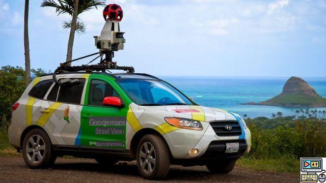
Google Street View allows you to view places as if you were there and this option is also available on mobile. However, to access it, it's not quite the same as on a PC. Here is how to do it:
- Enter an address in the search bar
- Place your finger on the address at the bottom of the screen and swipe up
- Click on Street View
To read : Google Street View has its own app
Place a marker on the map
If you were to visit a place that is not referenced on the application, the trick that allows you to place a landmark will be very useful to you to be able to find it later. To do this, you just need to do a long press on the area for which you want to add a marker. You can then add a label as explained in the paragraph.
How to add stopovers to your route on Google Maps
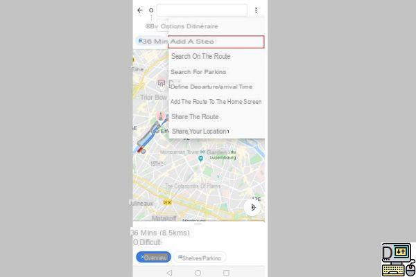
You can add stages to your route on Google Maps, very practical when going on vacation. So when you leave you can define stops in places you want to visit for example. The advantage is that suddenly Maps will estimate the time of arrival at the end point by counting the detours. Now let's see how to do it
- Open Maps and set your initial route
- Press the 3 small dots at the top right and do Add a step
- Add your step, you can add as many as you want
You can also rearrange the stages As you want it. Also note that adding stages to your route works just as well whether you are on foot, by car, by bike or by public transport. Then just let yourself be guided as you are used to doing with the application.
Navigate in augmented reality with Google Maps
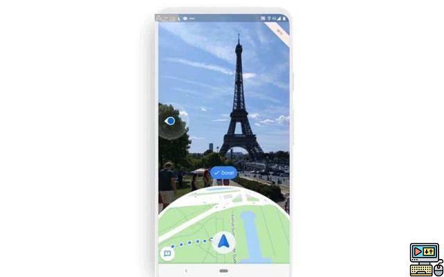
Google Maps has an augmented reality navigation mode. Thanks to artificial intelligence, the application adds elements intended to guide you on the view from the main photo sensor. For this, it will suffice to be in possession of an ARCore and ARKit compatible smartphone. Many models that are at least Android 7.0 Nougat support these technologies, but others require the presence of Android 8.0 Oreo. Please note, the mode is still being deployed. We explain how to launch the mode:
- Launch a route on Google Maps
- Select Display the route
There you have it, with all these tips you are sure to get lost with Google Maps and above all you are ready for your future holidays and weekends! If you know any other tips, don't hesitate to give them to us in the comments, we will be happy to add them to this guide.
Google Maps can save your home and workplace
Why register your home and your workplace? Quite simply because it is the basis for then being able to find strategic places near your home or your office, such as restaurants or shops. For that, here is the manipulation to do:
- Swipe from left to right to bring up the menu
- Select option Your addresses
- touch Home to enter your address then on Work to enter your office address